Katelyn & Bronson
Things To Do
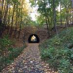
Dover Community Trail
The Dover Community Trail is a free, multi-use trail with breathtaking views of the Cochecho and Bellamy Rivers. Along the trail you will find ample scenic views, points of interest, and convenient access points along the 6.4 mile stretch. The trail also offers opportunities for bicycling, walking, hiking, bird watching, and fishing. The trail is comprised of two sections: a paved urban section stretching three-quarters of a mile from the Transportation Center to Fisher Street, and a natural section, two and a half miles long following the Cochecho River from Beckwith Ballfields to Watson Road. Difficulty rating - Easy https://www.dover.nh.gov/Assets/government/city-operations/2document/planning/mapping/Community%20Trail_Map.pdf
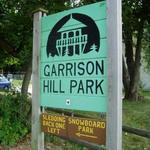
Garrison Hill Tower
Built in 1993, this observatory atop Garrison Hill is the third tower to exist on the hill. The park in which it stands is listed on the National Register of Historical Places. On a clear day, one can view the White Mountains and the Isles of Shoals. It also provides spectacular views of downtown Dover. Free entry.

Garrison City Beerworks
Nanobrewery and street taco kitchen in downtown Dover, NH with outdoor seating. They offer offer flights and full pours of all of our current 11 drafts, and a rotating menu of street tacos.
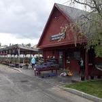
Tendercrop Farm at the Red Barn
Shop great local products, including produce and prepared food, at this local gem. Open daily from 9am to 6:30pm.
Woodman Museum
Dover's Woodman Institute offers an eclectic collection of natural science, local early history, and art. Open Wednesday through Sunday from 10am to 5pm. See website for admission pricing.

White Birch Armory
Indoor shooting range with axe throwing. Do not need a membership to access the range.
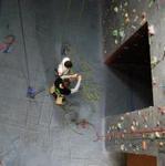
Indoor Ascent
Indoor rock climbing venue. They are open from 4pm-10pm Tuesday through Friday and from 10am-4pm on Saturday and Sunday. Visit their website for more information, including prices.
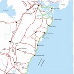
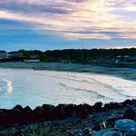
New Hampshire Coastal Byway - Scenic Drive
Drive the beautiful New Hampshire Seacoast using Routes 1A and 1B. Approximately 45-60 minutes, starting in Portsmouth and ending in Seabrook, NH. Please see the linked website for specifics.
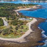
Odiorne Point State Park
Odiorne Point State Park offers one of the most beautiful natural settings along New Hampshire’s 18-mile coastline. Within the 135-acre seaside park, visitors can enjoy a wooded picnic grove, grassy fields, a playground and miles of walking trails. The New Hampshire Division of Parks and Recreation operates the park; the Center provides educational experiences at Odiorne Point State Park on behalf of New Hampshire State Parks. Free parking at pull-offs on Route 1A past the park entrance. Fee required to park on site and access the Seacoast Science Center.
Wallis Sands State Beach
Small public beach with restrooms. Payment required for entry/parking.

Portsmouth
Visit the quaint downtown Market Square in Portsmouth for shopping, bars, and restaurants. Stroll in and around the Strawbery Banks Museum to view historic homes and costumed staff demonstrating traditional crafts. Visit Prescott Park to view the beautiful riverside gardens and boat docks. In the northwest section of the city you can find the USS Albacore, a former research submarine alongside a visitor center.

PiNZ Bowl
The one-stop entertainment destination for ALL ages featuring bowling, arcade games, axe throwing, virtual reality and laser tag plus a menu full of tasty American classics and hand-crafted drinks.
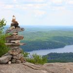
Mount Major Trail
Mt. Major Hike Info: Mt. Major Trail – 1.5 miles (to scenic vista at the top, marked with blue blazes) Boulder Loop Trail – 1.6 miles (from summit to trail head, marked with orange blazes) Elevation Gain – Approximately 1,100 feet Difficulty – Moderate Trailhead parking is located just off of Route 11 in the Mt. Major Parking Lot. Although it is a rather large parking lot, it does often fill up rather quickly on nice summer days. Luckily, however, parking is allowed near the lot on the side of Route 11. Maps and porta potties can be found in the parking lot and the trailheads are located at the far end.